Showing posts with label hiking. Show all posts

Thursday, April 17, 2014

Great Sand Dunes National Park and Preserve, Colorado


Colorado. Rocky Mountains. Forests. Farms. Water. The tallest sand dunes in North America. What? No kidding! Sprawling over 330 square miles, sand and sediment from the San Juan and Sangre de Cristo Mountain ranges blew and washed into what was once a huge lake. As the lake filled in, the gusty, year round wind piled the sand into dunes and continues to feed and shift the dunes today. The park contains nearly half the Dunes, while most of the rest are part of  a National Preserve in the Sangre de Cristo Wilderness.


Another anomaly of the park is that it contains 7 life zones and the many animals and plants that inhabit them. Rocky Mountain bighorn sheep can be found in Alpine Tundra; black bear roam Subalpine Forests; bobcats prowl among the pinon and juniper of Montane Forests; brightly colored tiger beetles liven up the Dunefields; elk wander the Grasslands; sandhill cranes patrol the Plains; finally, there are Streams and Wetlands, where beaver can sometimes be found. So this is Colorado after all.


I find the Dunes to be particularly striking during Lent. The stark barrenness of the dunefield summoned us into its emptiness. The mysterious undulations teased us into pursuing their secrets. Were there hidden spaces, or just endless drifts? Daddy couldn't resist removing his shoes to sink his feet into the soft, silky sand. I left my boots on. The wind was icy and the dunes were not reflecting the sun's warmth on this day.


As Yak crested a steep mound, the merciless wind stole his cowboy hat and deposited it playfully on the even steeper backside. Despite my dislike of vertical slopes, I judged that even if I rolled down to the bottom, the worst I would get would be sand in my hair, so I went after the headpiece. Halfway there I was creeping on all fours. Just as I was within reach of my goal, daddy clambered over the ridge and stopped right in front of the topper, laughing at me. Refusing to admit defeat, I pounced upon the hat and we all sat down on the backside of the dune, out of the sandstorm, for a much needed rest and a good laugh.
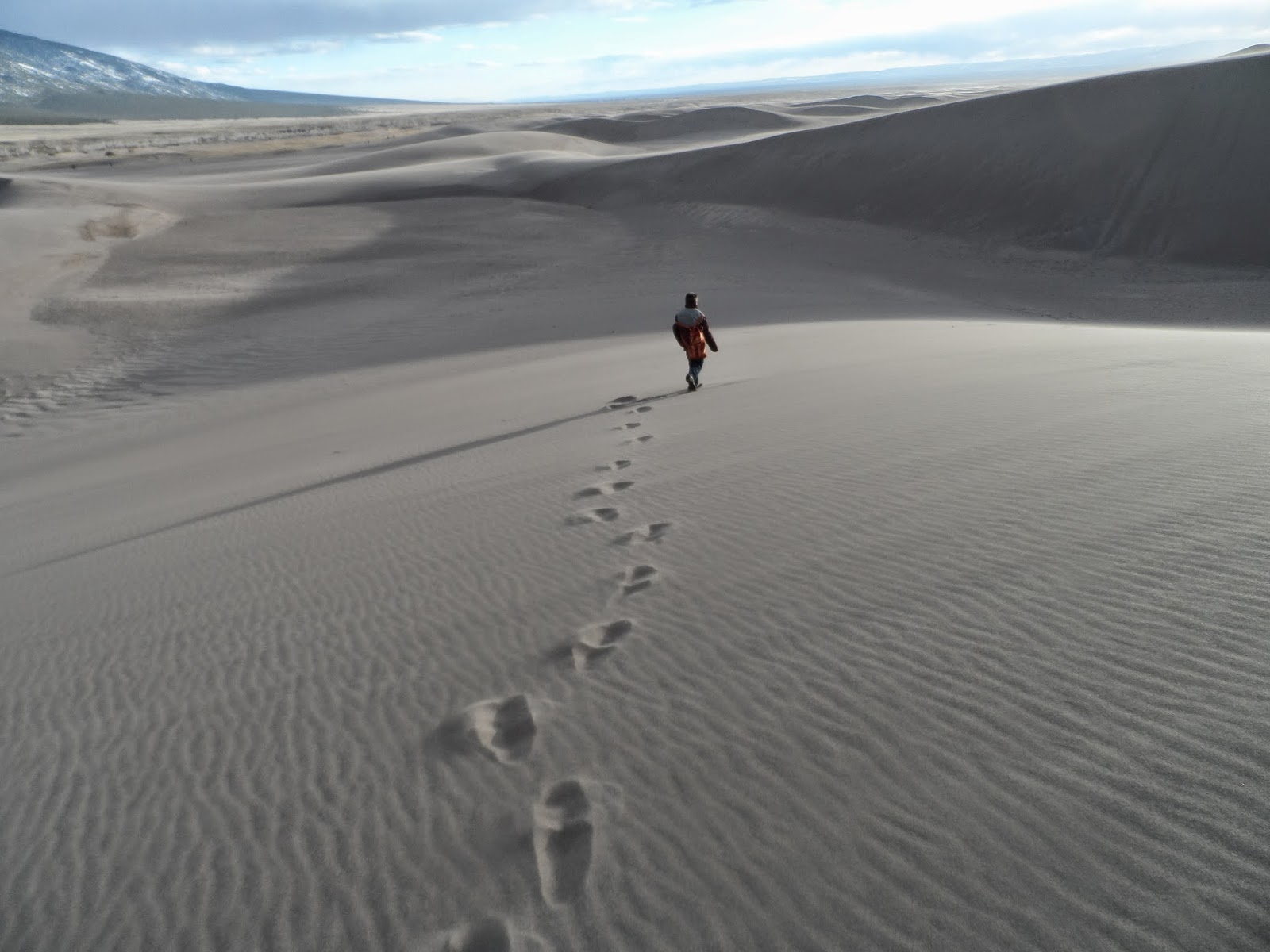


The wind was in our faces on the way back to the truck. I held securely to Yak's hat, not wishing to repeat my recent heroics. Any trace of our hike in was already blown away. The lenten journey is all here in the dunes. The emptying of myself. The overcoming of fear to serve another. Laughing at my shortcomings. Struggling uphill in the sand one way and against the wind the other. Reaching the truck never felt so good. Closing the door on the tempest. Turning on the heater. Making hot chocolate with the thermos of hot water I brought. The journey is difficult, we screw up along the way. The destination is worth it.

If you liked this post, you might enjoy:
White Horse Lake Trail, Williams, Arizona


Ireland's Rich Religious History
   
Grace to Climb Mountains
   
Were You There When The Sun Refused To Shine?


Saturday, October 19, 2013

Bill Williams Mountain Trail, Williams, Arizona


The perfect days of a Northern Arizona autumn are here, yet I am reflecting upon one of my favorite summer hikes. When the temperatures rise in Ash Fork, I take the boy up to Williams, where it's 5-10 degrees cooler, with a lot more shade. Bill Williams Mountain Trail #21, is the main trailhead located at the Williams Ranger Station. Several other trails can be accessed from it, including Clover Spring and City of Williams Link Trail. Bill Williams Mountain is a great day hike, though there are some fairly steep patches on the way up. For a beginning to intermediate hiker, this will just mean a few extra rest stops and a reminder that the return trip is all downhill. 


This trail wanders through ponderosa pines, oak, aspen and fir, with a bit of rock climbing thrown in. Well, not actually climbing, but for a 10 year old boy, we call it that. There are dozens of small dens to observe, most will be empty during the day, but have caution lest you come upon a sleeping critter or a new mother with her litter. Several viewpoints offer a glimpse of the town of Williams. You will likely hear the train whistle at some point, if you make the entire 6 mile round trip. The Grand Canyon Railway leaves Williams for the Canyon at 9:30a.m. and returns at 5:45p.m. daily.


The reward at the top of the trail is the Bill Williams Lookout tower, still occasionally manned by the Forest Service. If you're lucky, maybe you'll get invited up to take in the spectacular view, as a friend of mine did. One thing this same friend mentioned is that it is also possible to drive to the top on Forest Road 111, so if hiking is not for you, or if you just want to make the one way trip, you can still enjoy the mountain.


Though the trail is very clear, we still saw a few of these marking tapes (pink ribbon on the tree) along the way, hmm...
The yellow plate on this tree identifies it as a "bearing tree", a part of the Public Lands Survey System, identifying land boundaries and locations long before the GPS was even conceived.


As you can see here, Yak is carrying his walking stick. We don't always use them, but they are very helpful. He's also got water and gatorade easily accessible from the outside pockets of his daypack. Inside, I happen to know, are an apple, chips, a granola bar and a camera, notebook and pen. He also has a hoodie and hat stowed in there. Even if you think you're just going on a short hike, it's a good idea to be prepared. You never know what's up around the bend...

Happy Trails!

If you enjoyed this post you might enjoy these:


Clover Spring Trail, Williams, Arizona

Wednesday, October 2, 2013

Sycamore Canyon Overlook Trail, Williams, Arizona

Junction: Whitehorse Lake Trail and Sycamore Canyon Overlook Trail #70
While the government shut-down is affecting many services, including the National Parks and Forests, there are still a lot of activities available, if you're willing to walk just a little bit farther from your car, and pack a few snacks and a bottle of water in your daypack. The Sycamore Canyon Overlook Trail, #70, just outside of Williams, Arizona, meets up with the Whitehorse Lake Trail, #33. Another easy day-hike, it has a brief uphill climb, and is difficult to see in some spots. For me, this only added to the adventure. At trail marker 9 on the Whitehorse Lake Trail, take the trail to Sycamore Canyon View. This will make your hike a total of just over 3 miles, unless you have to park outside the Whitehorse Lake Campground and walk in to the trailhead. The reward is a mostly easy, fairly level trail, with abundant opportunities for wildlife viewing (especially with fewer people about) and interesting obstacles, such as these cattle gates, to negotiate.


I was standing right here, when a large hawk rose out of the canyon below and hovered in front of me. Noting his audience, he began to soar high overhead, dipping and rising on the air currents. My heart thrilled and I forgot to breathe for a moment. I sat and watched a small group of hawks dance on the winds for the better part of an hour.

The Dragon Tree
My mind, thus freed from its carefully constructed restraints, discovered this Dragon, cleverly disguised as a tree, apparently waiting either for its rider, or for some hobbit to try to steal its treasure. I was not going to fall for its tricks. The sun was setting, so I reluctantly returned down to the trailhead, mindful of the couple of spots where the trail was not very clear. 10 year old Yak would have enjoyed this hike, but at the time, the guys were in Colorado, so I had to go solo.


If you decide to take this hike, keep in mind that at the top, there are steep dropoffs and no safety rails. Keep young children close. Also, wildlife is not always friendly. Know how to protect yourself. Especially with Forest Rangers not on duty due to budget constraints, make sure somebody expects you back, so someone can alert authorities if you don't show up.

That said, Happy Trails!

Tuesday, September 10, 2013

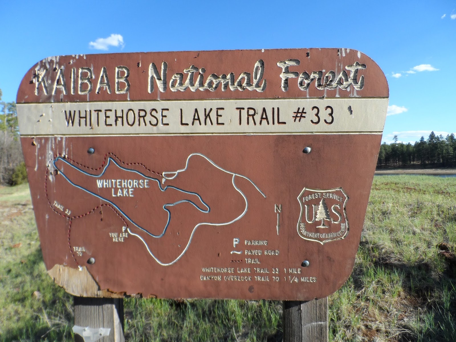
Whitehorse Lake Trail, Williams, Arizona


Late in May, I found myself in Williams, with my car pointed down the "south road" (aka 4th Street) out of town. The warm sun, the brilliant blue sky and the seductive scent of pine lured me on to where 4th Street becomes Perkinsville Rd. past the back side of Bill Williams Mountain. At the signpost for Overland Trails and Whitehorse Lake, I made a left. Another left into Whitehorse Lake campground, passed through to the day use area and parked. 


Sycamore Rim Trail Access Map


After changing into my trusty hiking boots, I grabbed walking stick, hat, camera, water and snacks. Okay, so it's only 1 mile from the parking area to the end of the trail and 1 mile back. My out of shape self was taking no chances. Part of my strategy in choosing this trail was that it is easy. The terrain is fairly level, no boulders to climb or streams to cross. It meanders through Ponderosa pine and oaks, so is mostly shady, and stays near the lake. If you're lucky, you might catch a glimpse of elk or deer, but be cautious of other wildlife. Puma have also been spotted, along with the occasional bear. I didn't even spot a fish on the day I went, but then, I didn't spot many people, either.


Don't plan on cooling off in the lake after your hike, as it is not aerated for swimming. Fish and Game does keep Whitehorse Lake stocked with trout, so bring your pole and license. Barbeques and tables are available for day use, for a fee, and the campground is right there. You might want to plan a few days at this spot, fishing, exploring the trails and relaxing and enjoying the tall pines, gazillion stars and spectacular sunrises and sunsets. Best time to go is May-October.


This trail is great for families, children, adults getting in shape/back in shape, older adults and experienced walkers. It also joins up with the Sycamore Canyon Overlook Trail which joins several other trails, for a change of scenery and more of a challenge. More info and maps are available at the Williams Ranger District office, right off Interstate 40 at exit 161 map.

Thursday, December 13, 2012

A Pilgrimage To The Park?


A pilgrimage to your local park?  Why not?  It's close by, probably has some green stuff (ie., trees, grass, etc.), maybe some water (lake), and probably some picnic tables to eat your lunch at.  Maybe you should throw an old blanket in the car, just in case. 


Once there, take a few moments to breathe deeply, exhale slowly, then see what's for lunch.  Even a couple of rolls and a hunk of cheese can be a feast in these surroundings.  When you finish eating, close your eyes for a few moments and just let your mind drift, while you take slow, deep breaths.  Don't fall asleep!  


Now open your eyes and look around you.  See if you still have time for a brisk walk around the baseball field or other safe path.  Spend your last few minutes taking in the cool greens, the soft rustle of the breeze in the leaves, the still waters of the lake, the innocence of children playing in the playground.  Whatever your local park features, you can most likely use it to relax and unwind for a few minutes, especially if the price of gas is keeping you from venturing much further.

I enjoy visiting the local park wherever I happen to be.  No two are exactly the same.  Some have quirky, creative play areas and trails. Some have lakes and trees.  Some have swimming pools or bike paths or skate parks.  Parks also tend to be kid- and pet-friendly.  A community park reflects its community.

If you don't have the time or money for a longer journey, try your local park!

Tuesday, September 4, 2012

Clover Spring Trail, Williams, AZ


Turn off from Bill Williams Lookout Trail

Took the Li'l Guy up to Williams (AZ) the other day, for some hiking.  We stopped at the Williams District Ranger Station, off Interstate 40, exit 161.  The office was closed, as it was a Saturday, but the trail head was open.  In spite of there being five other vehicles parked, we didn't encounter anyone on our trail until we were nearly back to our car.

Clover Spring Trail Map

The trail to Clover Spring starts at the Williams Ranger Station.  You can also start from Buckskinner Park in Williams, or Sheridan St. downtown.  From the Ranger Station, take the Bill Williams Mountain Trail, #21, for about 1/4 mile, then make a left onto the Clover Spring Trail, #46.  That's your turnoff sign, pictured above.  The 3/4 mile trail meanders through ponderosa pines, oaks, and rare alligator junipers.

The trail is easy, with just a few rock steps set into the path, but it showed me how quickly I can get out of shape.  Even my hiking boots felt heavy!  Note to self - do NOT wear tight denim skirt for hiking - full skirt is a must.  It feels so wonderful to be back in the pines after 4-1/2 months in the city.   Up near the spring, we startled a young deer and enjoyed the sight of it bounding away.

Clover Spring
Clover Spring is a natural spring, once used for domestic purposes, but now only safe for wildlife.  Bring your water purifier if you want to drink!  The water level was almost a foot below the drip pipe when we were there, and didn't look too appealing.

The return trip was all downhill.  Lots of big rocks for young-uns to climb, and side attractions for them to explore.  We were out early enough to hear the Grand Canyon Railway down in Williams blast its farewell for its daily run up to the canyon.


If you want a longer hike, you can continue past Clover Spring to Buckskinner Park - bring your picnic - or take the loop back to the junction with Trail #124, City of Williams Link Trail, and explore downtown Williams.  There are several great restaurants and lots of shops offering everything from Indian jewelry to custom leatherwork to Route 66 souvenirs.  When you're ready to go back to your car, take Trail #124 back to #46 and end up at the Ranger Station.

Tuesday, October 19, 2010

Canticle of the Sun - Thoughts on Wind and Weather

"Be praised, my Lord, through Brothers Wind and Air, and clouds and storms, and all the weather, through which you give your creatures sustenance."


I try to call to mind this verse of St. Francis of Assisi's Canticle of the Sun when the wind is ripping shingles off my roof, or blowing sheets of dirt into my face and hair.  Meditating on it at these times helps calm my irritation as I accept that such winds are usually blowing gloomy weather away from my little homestead, or bringing nourishing rain and playful snow to it - depends on my perspective, doesn't it? 


When I am hiking in the wind, if I stand still and close my eyes, I can feel Brother Wind embracing me, Brother Air infusing my body with healing oxygen, sensuous scents of evergreen, rain or snow, and sweet musky fragrances of flowers and mosses.


There is an anecdote about John Muir, the great naturalist, who was said to go for one of his "walks" in a storm, climb a tree and swing from the branches, just to let the wind and rain buffet and refresh him.  In his own words, he felt "...free to take the wind into my pulses and enjoy the excited forest...I kept my lofty perch for hours, frequently closing my eyes to enjoy the music by itself, or to feast quietly on the delicious fragrance that was streaming past."  (John Muir, The Mountains of California). 


I too have had the hours pass swiftly as I sat upon a lofty peak (though not up in a tree!) feeling the wind wash me of my anxieties, cleanse me of my materialism and make me ready to face my human brothers and sisters again, with renewed tolerance, compassion and love.

All praise and glory to God, the awesome Creator!